Best time to visit Big Sur
Re-score for me — drag the dial — every chart on the page recolours live for your heat limit 27°C
Default 27 °C is the upper edge of the Holiday Climate Index "ideal comfort" band (Scott, Rutty, Amelung & Tang, 2016). Above this, most warm-tourism travellers report measurable discomfort.
How is this scored? HCI / Steadman / CCI gate — full methodology and citations below.
Compare with another destination
Add as many as you like — stacked below the main strips above. Each row is just the recent-window score strip and (for beach destinations) sea-temperature strip.
Tours in Big Sur
12 top-rated tours via Viator. Booking links earn this site a commission at no cost to you. Map locations are approximate (centred on Big Sur).
- 1
 Big Sur McWay Falls opt 4 or 5 Hour Private Tour up to 12 ppl
 - 2
 Big Sur Monterey and Carmel Tour From San Francisco
 - 3
 Big Sur Monterey California Coast from San Jose 1 - 12 people
 - 4
 PCH: Big Sur Self-Guided Audio Tour from Monterey & Morro Bay
 - 5
 Driving the California Coast: A Self-Guided Audio Tour
 - 6
 Self-Guided Audio Driving Tour in Big Sur PCH Highway 1
 - 7
 Big Sur Sightseeing Tour
 - 8
 Big Sur Electric Bike Tour Along Old Coast Road
 - 9
 Private Tour of California's Central Coast (San Luis Obispo-Paso Robles-Cambria)
 - 10
 Highway 1 Pacific Coast Highway Self-Guided Driving Audio Tour
 - 11
 Smartphone Driving Tour between Santa Maria & Monterey 'Big Sur'
 - 12
 Half Day Private Big Sur Driving Tour in California
Last refreshed 2026-08-13.
Similar climatesSan Francisco93% · Yosemite89% · Ronda86%
Other destinations with the most-alike year-round climate to Big Sur (apparent temperature, rain hours, sunshine — matched within the same trip-profile). The ±N chip compares each match's typical score for the current month against Big Sur's. Based on the 2020-2024 climatology, not this year's actual weather.
Month-by-month
| Month | Temp °C | Feels °C | Rain days | Rain h | Rain h/day | Humidity | Wind km/h | Sun h | UV | Interest | Score |
|---|---|---|---|---|---|---|---|---|---|---|---|
| Jan | 10–15 | 13 | 9 | 126 | 14.0 | 70% | 22 | 172 | 2 | Peak | 6 |
| Feb | 9–15 | 12 | 7 | 105 | 15.0 | 65% | 21 | 192 | 3 | Moderate | 7 |
| Mar | 9–14 | 11 | 13 | 186 | 14.3 | 71% | 22 | 211 | 5 | Busy | 5 |
| Apr | 10–15 | 13 | 4 | 63 | 15.8 | 71% | 23 | 256 | 7 | Busy | 8 |
| May | 11–17 | 15 | 2 | 43 | 21.5 | 69% | 23 | 295 | 8 | Busy | 8 |
| Jun | 13–19 | 17 | 1 | 10 | 10.0 | 64% | 23 | 299 | 9 | Peak | 9 |
| Jul | 15–20 | 19 | 0 | 1 | — | 64% | 21 | 311 | 9 | Peak | 9 |
| Aug | 16–22 | 21 | 0 | 2 | — | 63% | 21 | 292 | 8 | Busy | 9 |
| Sep | 16–22 | 21 | 1 | 17 | 17.0 | 62% | 19 | 261 | 7 | Quiet | 9 |
| Oct | 15–21 | 20 | 2 | 27 | 13.5 | 57% | 18 | 236 | 5 | Quiet | 10 |
| Nov | 11–18 | 15 | 6 | 65 | 10.8 | 60% | 20 | 201 | 3 | Quiet | 8 |
| Dec | 10–16 | 13 | 11 | 151 | 13.7 | 69% | 19 | 165 | 2 | Quiet | 6 |
UV Index in Big Sur by Month
UV index in Big Sur peaks at 9 (very high) in July, dropping to 2 (low) in December. June, July, August reach very high or extreme levels — apply SPF 50+, wear a hat and protective clothing, and limit direct sun between 11:00 and 17:00.
Best months in detail
October
10/1015–21°C (feels 20°C) · 2 rain days (27h) · 236 sun hours · 57% humidity · Quiet crowd · UV 5 (moderate) · sunniest 1 in 10 days reach 6 (high)
August
9/1016–22°C (feels 21°C) · 0 rain days (2h) · 292 sun hours · 63% humidity · Busy crowd · UV 8 (very high)
September
9/1016–22°C · 1 rain days (17h) · 261 sun hours · 62% humidity · Quiet crowd · UV 7 (high) · sunniest 1 in 10 days reach 8 (very high)
Every month
Show the other 9 months in detail
January
6/1010–15°C (feels 13°C) · 9 rain days (126h) · 172 sun hours · 70% humidity · Peak crowd · UV 2 (low)
February
7/109–15°C (feels 12°C) · 7 rain days (105h) · 192 sun hours · 65% humidity · Moderate crowd · UV 3 (moderate)
March
5/109–14°C (feels 11°C) · 13 rain days (186h) · 211 sun hours · 71% humidity · Busy crowd · UV 5 (moderate) · sunniest 1 in 10 days reach 7 (high)
April
8/1010–15°C (feels 13°C) · 4 rain days (63h) · 256 sun hours · 71% humidity · Busy crowd · UV 7 (high) · sunniest 1 in 10 days reach 8 (very high)
May
8/1011–17°C (feels 15°C) · 2 rain days (43h) · 295 sun hours · 69% humidity · Busy crowd · UV 8 (high) · sunniest 1 in 10 days reach 9 (very high)
June
9/1013–19°C (feels 17°C) · 1 rain days (10h) · 299 sun hours · 64% humidity · Peak crowd · UV 9 (very high) · sunniest 1 in 10 days reach 10 (very high)
July
9/1015–20°C (feels 19°C) · 0 rain days (1h) · 311 sun hours · 64% humidity · Peak crowd · UV 9 (very high)
November
8/1011–18°C (feels 15°C) · 6 rain days (65h) · 201 sun hours · 60% humidity · Quiet crowd · UV 3 (low) · sunniest 1 in 10 days reach 4 (moderate)
December
6/1010–16°C (feels 13°C) · 11 rain days (151h) · 165 sun hours · 69% humidity · Quiet crowd · UV 2 (low)
One road serves the whole coast, and it keeps falling into the sea
Big Sur is not a park with an entrance; it is roughly 140 km of coast served by a single road, Highway 1. When that road closes, sections of the coast become unreachable from one direction or the other, and it closes often.
The recent pattern shows how quickly things move. Highway 1 at Regent's Slide reopened on 14 January 2026, months ahead of an estimated March date. A month later, on 17 February 2026, a 6.8-mile segment closed again — from two miles north of Lucia to one mile south of the Esalen Institute — after winter storms eroded debris into the catchment area, overtopping the barriers and putting rock on the carriageway. Caltrans gave no estimate for reopening.
This is why Big Sur's season is really a road season. The weather matters mostly through what it does to the slope above the highway.
Sources: Caltrans District 5 — Highway 1 on Big Sur coast remains closed near Regent's Slide , Big Sur Chamber of Commerce — Highway 1 conditions
What is the best month to go to Big Sur?
September and October. The summer fog that blankets the coast in June and July has cleared, the winter storms that close Highway 1 have not yet arrived, and the crowds have thinned. April and May are the next best, with green hillsides and wildflowers.
How many days are needed for Big Sur?
Two days. The drive itself takes two to three hours without stopping, but the point is stopping — Bixby Bridge, McWay Falls, Pfeiffer Beach and the redwood parks. One day is a rushed drive-through; two lets you walk and catch a sunset over the ocean.
Is it better to stay in Carmel or Big Sur?
Carmel has far more choice, restaurants and reliable mobile signal, and puts you at the northern end of the drive. Staying in Big Sur itself is more expensive and more limited, but places you among the redwoods for sunrise and sunset, and avoids driving the winding road twice.
Is Highway 1 through Big Sur open?
It varies, and it changes fast. The Regent's Slide section reopened in January 2026 and closed again in February 2026 after storm debris reached the carriageway. Always check the Caltrans District 5 updates before travelling, because a closure can add hours of inland detour.
What month has the best weather in Big Sur?
September and October. Summer brings persistent coastal fog that can hide the view for days, and winter brings the storms that close Highway 1 — February is the wettest month at around 143 mm. Early autumn threads between the two, with clear air, warm days near 23C and the road usually open.
Does it rain a lot in Big Sur?
Seasonally, yes. February averages around 143 mm while July is essentially dry at about 1 mm. The rain matters less for comfort than for access: winter storms saturate the slopes above Highway 1 and trigger the landslides that close the road, sometimes for months at a time.
Is the road to Big Sur scary?
Highway 1 is winding, narrow in places, and runs along cliff edges with sheer drops to the ocean, so nervous drivers find the southbound side — nearest the drop — uncomfortable. It is well engineered and has no extreme gradients. Drive it northbound to keep the inland lane, allow far more time than the distance suggests, and use the turnouts.
What is the most beautiful part of Big Sur?
The stretch between Bixby Bridge and McWay Falls holds most of the famous views, including the Bixby Creek Bridge itself and the waterfall dropping straight onto the beach at Julia Pfeiffer Burns State Park. Pfeiffer Beach, with its purple sand and rock arch, is the other highlight, reached by an easily missed side road.
How many days do I need in Big Sur?
Two. The drive takes two to three hours without stopping, but stopping is the point — Bixby Bridge, McWay Falls, Pfeiffer Beach and the redwood parks. One day is a rushed transit; two lets you walk a trail, catch a sunset over the Pacific and absorb a closure or detour without losing the trip.
What is Big Sur famous for?
The meeting of the Santa Lucia Mountains and the Pacific, and the road that threads between them — Highway 1, cut into the cliffs in the 1930s. Bixby Creek Bridge and McWay Falls, which drops onto a beach, are the two most photographed points. There is no town as such: Big Sur is a stretch of coast roughly 140 km long.
Is Big Sur worth visiting?
Yes, though manage expectations about what it is — a drive with stops and short walks, not a destination with a centre. The coastline is among the most dramatic anywhere reachable by road. The real risk is access: Highway 1 closes regularly after winter storms, and a closure can add hours of inland detour, so check status before committing.
Which is better, Big Sur or Yosemite?
Different trips entirely. Big Sur is coastal, low-effort and best done as a two-day drive with stops; Yosemite is an inland granite valley demanding hikes and more time. Big Sur suits a weekend from San Francisco and is at its best in September and October, when fog has cleared and storms have not started. Yosemite rewards a longer stay.
Frequently asked questions about visiting Big Sur
When is the best time to visit Big Sur?
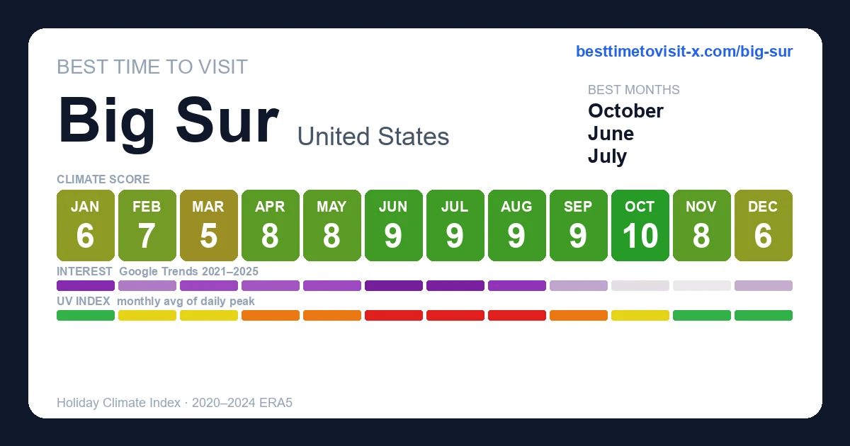
October is the highest-scoring month (10/10 on the Holiday Climate Index). Typical conditions: 15–21°C (2 rainy days). The top three months by score are October, August, September.
What is the worst time to visit Big Sur?
March is the lowest-scoring month (5/10). Typical conditions: 9–14°C (13 rainy days).
When are crowds lowest in Big Sur?
Search-interest seasonality (Google Trends 2021-2025) is lowest in November and peaks in June. Interest tracks both in-trip visitors and lead-time planners, so treat it as a "destination is on people's minds" signal rather than literal arrivals.
Which months in Big Sur have good weather but fewer tourists?
October (climate 10/10, crowd index 6) and September (climate 9/10, crowd index 35) — shoulder months with above-average climate and below-median search-interest. Often the best value-for-weather trade.
What is the UV index in Big Sur by month?
UV peaks at 9 (very high) in July and is lowest in December at 2 (low). Monthly peak values: Jan 2, Feb 3, Mar 5, Apr 7, May 8, Jun 9, Jul 9, Aug 8, Sep 7, Oct 5, Nov 3, Dec 2. June, July, August reach very high or extreme levels — apply SPF 50+, wear a hat and protective clothing, and limit direct sun between 11:00 and 17:00.
What is the UV index in Big Sur in July?
July is the peak UV month in Big Sur, with a daily-peak UV index of 9 (very high). At this level, sunburn can occur in under 20 minutes on unprotected fair skin. Apply SPF 50+, wear protective clothing and a hat, and avoid direct midday sun (11:00–17:00).
How high can UV get in Big Sur on the sunniest days?
Most days look like the monthly average, but on the sunniest ~1 in 10 days UV climbs higher than the mean suggests. June is the worst case: typical days average UV 9 (very high), but the top 10% of days reach UV 10 (very high) — and even higher. Months where the sunniest days routinely exceed the typical reading: March, April, May, June, September, October, November. Plan sun protection for the worst case, not the average.